

As a new student member of the California Map Society, I was delighted to have the opportunity to attend the Society’s conference at Stanford University on 2 May 2015. The speakers covered a range of fascinating topics. For the next few weeks, I’ll be sharing my notes from each talk from the event in separate blog posts.
“Ancient Orientations: Roman Maps of India” – Grant Parker
Professor Grant Parker spoke about Roman maps of India despite the lack of visual records and evidence from classical times. In other words, the maps from the time are missing, but Roman understandings of India as a place may be reconstructed through available textual records.
Some of the available texts for this effort that he touched upon included:
1) Periplus Maris Erythraei (“Voyage around the Erythraean Sea”), a transcript of practical considerations for traveling from Egypt to India that lists trade goods to carry and details weather conditions during monsoon season (from circa 40-70 CE):
The ships lie at anchor at Barbaricum, but all their cargoes are carried up to the metropolis by the river, to the King. There are imported into this market a great deal of thin clothing, and a little spurious; figured linens, topaz, coral, storax, frankincense, vessels of glass, silver and gold plate, and a little wine. On the other hand there are exported costus, bdellium, lycium, nard, turquoise, lapis lazuli, Seric skins, cotton cloth, silk yarn, and indigo. And sailors set out thither with the Indian Etesian winds, about the month of July, that is Epiphi: it is more dangerous then, but through these winds the voyage is more direct, and sooner completed.
2) Strabo’s The Geography
3) Pliny’s Natural History
4) Ptolemy’s Geographical Guide (a “recipe of how to make maps”)
!["[Map of India]," Ptolemy, Cosmographia, 1482.](https://dessertating.wordpress.com/wp-content/uploads/2015/05/1796255725bc30be1a133d8a46467507.jpg?w=300&h=238)
“[Map of India],” Ptolemy, Cosmographia, 1482.

As Parker explained, this seven meter map scroll was not for travel but rather for display and, likely, propagandistic uses.
6) The Vicarello Goblets, engraved with an itinerary listing distances between Rome and Cadiz (as well as other cities):
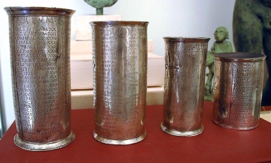
Like the Peutinger Map (but unlike AAA highway guides), these were not used for travel, although they did offer a practical representation of space and serve as a travel guide.
7) Cosmas Indicopleustes, written by a trader who became a monk:

He was also a flat-earther who thought the world was shaped like the tabernacle.
9) Roman classroom maps, as mentioned in a speech by Eumenius:
…[N]ow at last it is a delight to examine a picture of the world, since we see nothing in it which is not ours.
In conclusion, Parker noted, “It’s clear that there are many Indias here.” He urged wariness for scholars, particularly around questions of local knowledge, intended audiences for map, and the provenance of source material. For example, he said, “the Artemidorus papyrus, with its many puzzles, poses intriguing questions about the nature of Roman map-mindedness.”
Further Reading:
– Richard J.A. Talbert, Rome’s World: The Peutinger Map Reconsidered, Cambridge University Press, 2010.
– David N. Livingstone, The Geographical Tradition: Episodes in the History of a Contested Enterprise, 1992.

Pingback: California Map Society & Stanford Lecture Series Notes | This dissertation is going to be fun, like dessert