
After a series of hilarious incidents during which I ate half of someone else’s grilled cheese and ice cream sundae, then couldn’t find the campus shuttle due to a failure to read maps correctly… I wound up at the California Map Society & Stanford Lecture Series only a little bit later than I had originally planned.*
California Map Society & Stanford Lecture Series
I attended the student paper presentation at the David Rumsey Map Center in the Cecil H. Green Library at Stanford University on 4 May 2017. It. Was. AWESOME. There were giant monitors around the room for viewing maps, and neat spinning globes atop every shelf. The David Rumsey Historical Map Collection has been an invaluable on-line tool for my research and teaching, so it was really cool to go to a room dedicated to preserving and displaying the collection.
The student talk was based on materials from the collection and the speaker had won an award for her essay. (I’m definitely planning to include her name and institutional affiliation as soon as those become available on the California Map Society page. As I was late due to terrible map-reading skillz, I missed those important details.)
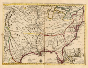
She was speaking about two maps by Guillaume de L’Isle and [???] (I’m waiting for the paper to become available to get the spelling of the second mapmaker’s name). She noted the emphasis in each map on the abundance of commodities and commercial potential for the Louisiana Territory. Both mention “The Heart of the River” in their titles (any one have ideas as to why? Theories accepted in the comments). The focus on the river routes and fur trade was particularly relevant to my area of interest, of course (CANADA).
The rivers were crucial to the expansion of French fur trading, transportation, communication, and missionary efforts, a point reflected by their prominent role in each map. She mentioned Native American / First Nation birch bark canoe and sled use, which were both copied by the French. However, overland trails such as buffalo routes were generally avoided by the French, who preferred the ease of access afforded by the rivers. By 1685, there were French trading posts around the Great Lakes, with missions established nearby.
She mentioned the travels of Louis Joliet and Jacques Marquette (a Jesuit who’s rather infamous in the Chicagoland area) along the Mississippi River through to Spanish territory in 1673. The Governor of New France, Frontenac, footed Joliet’s expedition bill. In 1682, de La Salle travelled with Louis Hennepin (a Franciscan whom she classified as “a bit of a scoundrel”) along a similar route. The maps celebrate 19,000 miles of navigable waterways — but, she asked, “what are they hiding?”
She noted that the maps have a celebratory tone about the French voyages along the Mississippi, and the missionaries even baptized the territory in the name of France, but their tone belies chronic uncertainty about the Louisiana Territory. The area was a burden for the French crown, which was concurrently engaged in various European wars. Even map inscriptions like “La Floride” on Delisle’s map betray the dominance of Spanish claims.
The frantic “race to the Gulf of Mexico” by D’Iberville (who named Mobile and Beloxy in 1700) was tempered by British colonization, religious strife, and poor agricultural opportunities. (I’m not sure if this was a joke or a quote, but she noted that there were no pearl or buffalo exports possible from the region.)
John Law revived French interest in the region, but John Law’s Company of the West ultimately proved too good to be true. In the “Mississippi Bubble,” his self-made currency collapsed, and he was ultimately dismissed in 1720.
In 1729, there was a bloody fight at Natchez, which had formerly been considered the gem of the region. Overall, Louisiana was plagued with geopolitical instability.
There were many intertribal conflicts, but also exchanges, collaborations, and unstable British and French alliances with Indigenous communities. Overall, the maps tend to conceal any conflict. She argued that despite the violent imagery in a cartouche of a Native American figure carrying a scalp, this was merely stock iconography.
Furthermore, maps conceal the asymmetrical distances. While one may reach New Orleans downstream two weeks after leaving Kaskaskia, the return journey might be a four month upstream slog. (Fun facts about New Orleans from the Q&A: Among other factors… it was too hard to travel much further upstream, especially when larger ships were involved, so New Orleans was founded in a floodplain in 1718.)
Some discrepancies between the maps that she noted were in the illustration of tributaries and the naming conventions. For example, de L’Isle’s 1703 map includes Mexique et Floride as opposed to drawings of turkeys. There was plenty of copying and referencing of earlier maps; she called mapmaking “a cumulative textual process.”
I noticed that the Carte du Canada cartouche included a beaver (*nod to some NEH participants…*) as well as a “much more edifying bunch of cattle.”
De L’Isle was the preeminent geographe du bois of his era, and the ‘accuracy’ of his maps served as a definitive reference point for decades.
Other topics she mentions:
- John Senex map – copied with name changes
- Native American contributions to mapmaking
- Jesuit navigation
- Imperial optimism about North America
- Processes of mapmaking
- Seven Years War
- Lake Erie’s alternative names (Lac Chat?)
- Quebec’s Jesuit hydrography and navigation school
- Apparently North and South Carolina (the Carolinas) were named after either a French or English king. Mapmakers carried on the dispute.
- Joliet made elaborate but sloppy maps, whereas Jesuits like Marquette made comparatively sophisticated, nuanced pieces of cartography.
The next talk was about Revolution: Mapping the Road to American Independence, but my childcare ran out!
Her paper should be available on the California Map Society website soon. I’ll update when I see it!
Abbreviated List of Further Sources
- Middle Ground by Richard White (recommended by speaker)
- The Royal Proclamation of 1763
- The Great Peace of Montreal of 1701 by Gilles Havard
- The Fur Trade in Canada: An Introduction to Canadian Economic History by Harold Innis
- The Upper Country by Claiborne Skinner
- “Black Robe“
- Anything that Nenette Luarca-Shoaf has to say about the Mississippi River!
—
California Map Society Conference posts from May 2015:
- “Ghosts of Former Indigenous Inhabitants of Stanford University”
- “The Arbuckle Illustrated Atlases”
- “Ancient Orientations”
- “Opening Up the Data Vault”
- Branner Library Tour
* And I had planned for this. It was an OUTING. I wore my cartographic skirt from DM, my cartographic scarf from JKZ, and my cartographic necklace from SS. I drew an apparently terrible map of the bus lines I needed to use. Plus I was carrying my Chicago Map Tote bag. What a cartographically-themed life I lead! Also I had gotten childcare.
